
Fitxer:Paris 4th.png
Mida d'aquesta previsualització: 728 × 600 píxels. Altres resolucions: 291 × 240 píxels | 583 × 480 píxels | 932 × 768 píxels | 1.200 × 989 píxels.
Fitxer original (1.200 × 989 píxels, mida del fitxer: 176 Ko, tipus MIME: image/png)
| Aquest fitxer i la informació mostrada a continuació provenen del dipòsit multimèdia lliure Wikimedia Commons. |
Resum
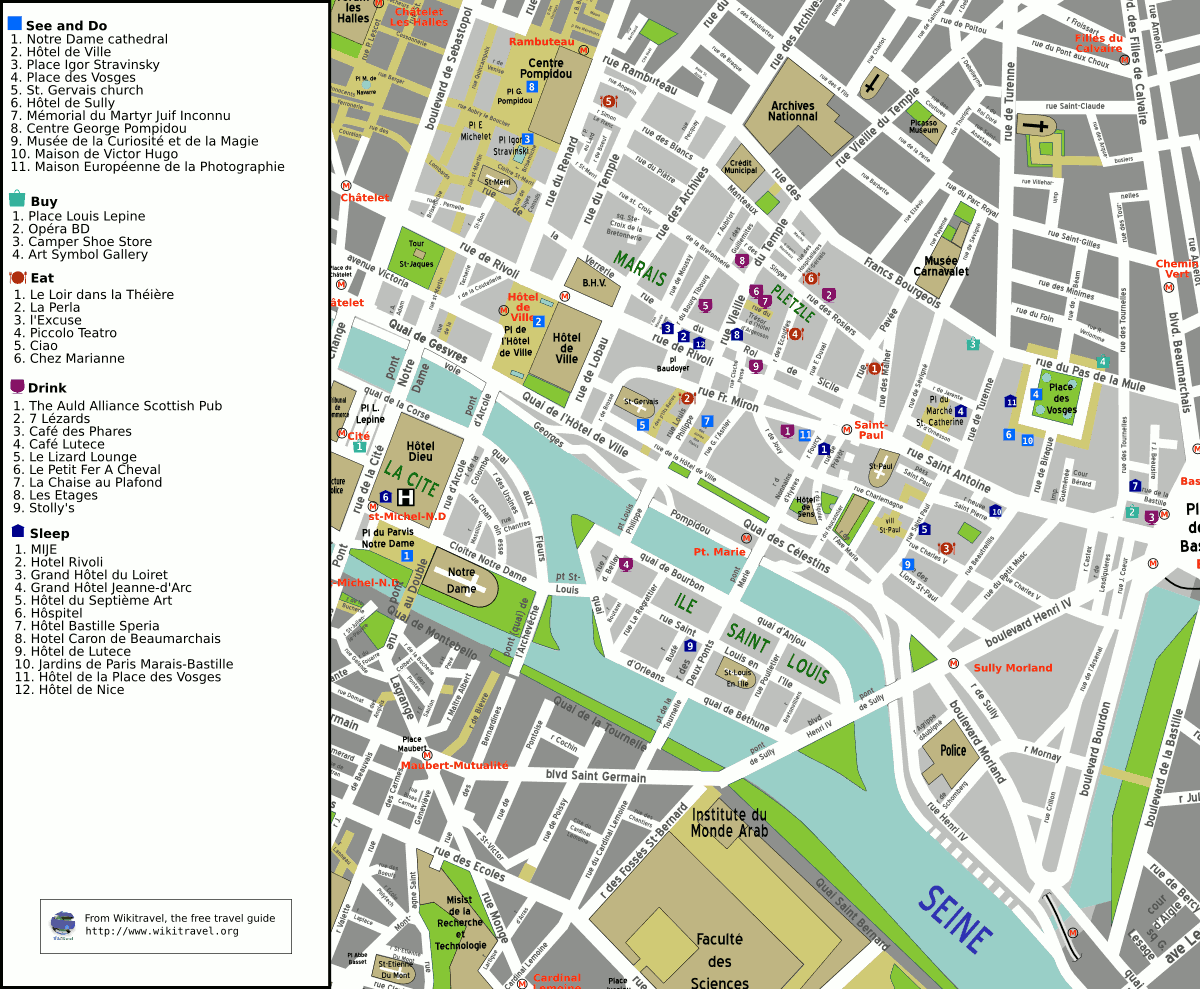
Map of the 4th arrondissement of Paris. Map created by Mark Jaroski for Wikitravel.
Copying
© Copyright 2005 by Mark Jaroski
This map is free content. You may redistribute it or your derivative work under the terms of the Creative Commons by-sa license versions 1 or 2.
Llicència
Aquest fitxer està publicat sota la llicència de Creative Commons Reconeixement i Compartir Igual 2.5 Genèrica.
- Sou lliure de:
- compartir – copiar, distribuir i comunicar públicament l'obra
- adaptar – fer-ne obres derivades
- Amb les condicions següents:
- reconeixement – Heu de donar la informació adequada sobre l'autor, proporcionar un enllaç a la llicència i indicar si s'han realitzat canvis. Podeu fer-ho amb qualsevol mitjà raonable, però de cap manera no suggereixi que l'autor us dóna suport o aprova l'ús que en feu.
- compartir igual – Si modifiqueu, transformeu, o generareu amb el material, haureu de distribuir les vostres contribucions sota una llicència similar o una de compatible com l'original
Registre original de càrregues
La pàgina de descripció original era aquí. Els noms d'usuari a continuació es refereixen a fr.wikivoyage-old.
- 2005-06-03 13:20 (WT-fr) Quirk 1200×989 (180269 bytes) ==Copying== © Copyright 2005 by Mark Jaroski This map is free content. You may redistribute it or your derivative work under the terms of the (Import from wikitravel.org/fr)
Historial del fitxer
Cliqueu una data/hora per veure el fitxer tal com era aleshores.
| Data/hora | Miniatura | Dimensions | Usuari/a | Comentari | |
|---|---|---|---|---|---|
| actual | 22:51, 18 set 2005 | | 1.200 × 989 (176 Ko) | Thbz | Map of the 4th arrondissement of Paris. Map created by [http://wikitravel.org/en/User:Mark Mark Jaroski] for Wikitravel. ==Copying== © Copyright 2005 by Mark Jaroski This map is free content. You may redistribute it or your derivative work under the t |
Ús del fitxer
La pàgina següent utilitza aquest fitxer:
Ús global del fitxer
Utilització d'aquest fitxer en altres wikis:
- Utilització a bs.wikipedia.org
- Utilització a de.wikipedia.org
- Utilització a el.wikipedia.org
- Utilització a en.wikipedia.org
- Utilització a en.wikivoyage.org
- Utilització a eo.wikipedia.org
- Utilització a es.wikipedia.org
- Utilització a eu.wikipedia.org
- Utilització a fi.wikipedia.org
- Utilització a fr.wikipedia.org
- Utilització a fr.wikivoyage.org
- Utilització a he.wikipedia.org
- Utilització a hy.wikipedia.org
- Utilització a it.wikipedia.org
- Utilització a ja.wikipedia.org
- Utilització a la.wikipedia.org
- Utilització a nl.wikipedia.org
- Utilització a no.wikipedia.org
- Utilització a ru.wikipedia.org
- Utilització a sk.wikipedia.org
- Utilització a sr.wikipedia.org
- Utilització a sv.wikipedia.org
- Utilització a uk.wikipedia.org
- Utilització a zh.wikipedia.org