
Fitxer:Baikal Amur Mainline map EN OSM 20170129.svg

Mida d'aquesta previsualització PNG del fitxer SVG: 800 × 376 píxels. Altres resolucions: 320 × 150 píxels | 640 × 301 píxels | 1.024 × 481 píxels | 1.280 × 602 píxels | 2.560 × 1.204 píxels | 938 × 441 píxels.
Fitxer original (fitxer SVG, nominalment 938 × 441 píxels, mida del fitxer: 6,14 Mo)
| Aquest fitxer i la informació mostrada a continuació provenen del dipòsit multimèdia lliure Wikimedia Commons. |
| Descripció |
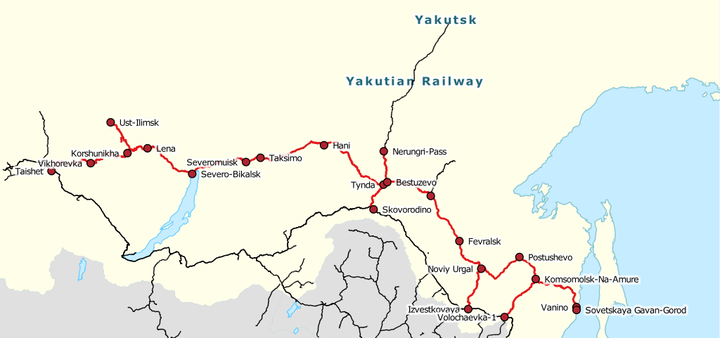
Русский: Схема Байкало-Амурской магистрали English: Baikal-Amur Mainline railway line. |
|||||||||
| Data | ||||||||||
| Font | openstreetmap.org | |||||||||
| Creador |
OpenStreetMap contributors |
|||||||||
| Permís (Com reutilitzar aquest fitxer) |
OpenStreetMap data is available under the Open Database License (details). Map tiles are licensed under the Creative Commons Attribution-ShareAlike 2.0 license (CC-BY-SA 2.0).
Aquest fitxer està publicat sota la llicència de Creative Commons Reconeixement i Compartir Igual 2.0 Genèrica.
|
|||||||||
| Geotemporal data | ||||||||||
| Bounding box |
|
|||||||||
| Georeferencing | If inappropriate please set warp_status = skip to hide. | |||||||||
| Altres versions | Baikal_Amur_Mainline_map_RU_OSM_20170129.svg | |||||||||
Historial del fitxer
Cliqueu una data/hora per veure el fitxer tal com era aleshores.
| Data/hora | Miniatura | Dimensions | Usuari/a | Comentari | |
|---|---|---|---|---|---|
| actual | 21:21, 30 gen 2017 | | 938 × 441 (6,14 Mo) | Svetlov Artem | {{OpenStreetMap |name = |location = |description ={{ru|1=Схема Байкало-Амурской магистрали}}{{en|1=Baikal-Amur Mainline railway line.}} |top = 62.7748 |bottom = 47.4281 |left =93.8672 |right =151.7871 |date = 2017... |
Ús del fitxer
Les 2 pàgines següents utilitzen aquest fitxer:
Ús global del fitxer
Utilització d'aquest fitxer en altres wikis:
- Utilització a be.wikipedia.org
- Utilització a de.wikivoyage.org
- Utilització a en.wikipedia.org
- Utilització a en.wikivoyage.org
- Utilització a es.wikipedia.org
- Utilització a he.wikipedia.org
- Utilització a ka.wikipedia.org
- Utilització a sv.wikipedia.org
- Utilització a tt.wikipedia.org
- Utilització a uk.wikipedia.org
- Utilització a www.wikidata.org