
Fitxer:Earth from Space- Pilbara, Western Australia ESA24830604.tiff

Fitxer original (12.140 × 9.008 píxels, mida del fitxer: 312,9 Mo, tipus MIME: image/tiff)
| Aquest fitxer i la informació mostrada a continuació provenen del dipòsit multimèdia lliure Wikimedia Commons. |
Resum
| Descripció |
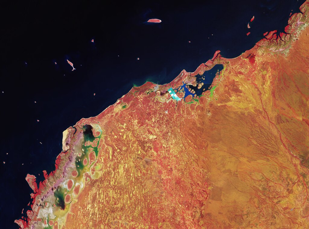
English: The Copernicus Sentinel-2 mission takes us over part of the northern coast of the Pilbara region in Western Australia. Zoom in to explore this image at its full 10 m resolution or click on the circles to learn more. As the image shows, the coast is a complex system of deltas, limestone barrier islands, salt ponds and lagoons. Captured on 5 March 2023 and processed in false-colour, the image offers information on vegetation. The processing involved using the mission’s near-infrared channel to help highlight the distribution, density and health of the vegetation in red. The healthier the plants are, the brighter red they appear. On the left, tidal channels and mangroves are also visible in red. Mangroves play an important role in preventing erosion and protecting the coastline from waves and storms. Round islands can be seen in the coastal lagoons. These are in contrast to the rectangular, white and blue ponds of the salt extraction industry in the Onslow Salt Lake to the east. Causeways divide the lake into three zones which help with the evaporation process. North of the Lake lies the coastal city of Onslow, with its airport clearly visible to the south of the city. In the bottom centre of the image, numerous catchments that collect water after rain are visible in gold – gold partly due to the presence of mud. Off the coast, a number of islands are scattered in the dark blue Indian Ocean waters. Their red appearance means that they are covered in vegetation. In fact, Pilbara islands are home to various nature reserves. Thevenard Island, the bigger island in the centre top of the image, is important for a wealth of marine wildlife such as sea turtles, dolphins, whales and fish. This image was selected, processed and planned for publication prior to the news that Cyclone Ilsa was heading for Western Australia. Reports state that it subsequently made landfall as a category 5 storm at a remote stretch of the coast, thankfully missing highly-populated areas. |
| Data | 14 d'abril de 2023 (upload date) |
| Font | Earth from Space: Pilbara, Western Australia |
| Autor | European Space Agency |
| Altres versions |
|
| Activity | Observing the Earth |
| Mission | Sentinel-2 |
| Set | Earth from Space image collection |
| System | Copernicus |

Llicència

|
This image contains data from a satellite in the Copernicus Programme, such as Sentinel-1, Sentinel-2 or Sentinel-3. Attribution is required when using this image.
Reconeixement: Contains modified Copernicus Sentinel data 2023
The use of Copernicus Sentinel Data is regulated under EU law (Commission Delegated Regulation (EU) No 1159/2013 and Regulation (EU) No 377/2014). Relevant excerpts:
Free access shall be given to GMES dedicated data [...] made available through GMES dissemination platforms [...].
Access to GMES dedicated data [...] shall be given for the purpose of the following use in so far as it is lawful:
GMES dedicated data [...] may be used worldwide without limitations in time.
GMES dedicated data and GMES service information are provided to users without any express or implied warranty, including as regards quality and suitability for any purpose. |
This media was created by the European Space Agency (ESA).
Where expressly so stated, images or videos are covered by the Creative Commons Attribution-ShareAlike 3.0 IGO (CC BY-SA 3.0 IGO) licence, ESA being an Intergovernmental Organisation (IGO), as defined by the CC BY-SA 3.0 IGO licence. The user is allowed under the terms and conditions of the CC BY-SA 3.0 IGO license to Reproduce, Distribute and Publicly Perform the ESA images and videos released under CC BY-SA 3.0 IGO licence and the Adaptations thereof, without further explicit permission being necessary, for as long as the user complies with the conditions and restrictions set forth in the CC BY-SA 3.0 IGO licence, these including that:
See the ESA Creative Commons copyright notice for complete information, and this article for additional details.
|
 | |
This file is licensed under the Creative Commons Attribution-ShareAlike 3.0 IGO license. Reconeixement: ESA, CC BY-SA IGO 3.0
| ||
Historial del fitxer
Cliqueu una data/hora per veure el fitxer tal com era aleshores.
| Data/hora | Miniatura | Dimensions | Usuari/a | Comentari | |
|---|---|---|---|---|---|
| actual | 21:43, 14 abr 2023 |  | 12.140 × 9.008 (312,9 Mo) | OptimusPrimeBot | #Spacemedia - Upload of https://esamultimedia.esa.int/img/2023/04/westaustralia_S2_20230305_CF_2.tif via Commons:Spacemedia |
Ús del fitxer
La pàgina següent utilitza aquest fitxer:
Ús global del fitxer
Utilització d'aquest fitxer en altres wikis: