
Fitxer:Fukushima I nuclear accidents radioactive cloud-en.svg

Fitxer original (fitxer SVG, nominalment 511 × 183 píxels, mida del fitxer: 2,86 Mo)
| Aquest fitxer i la informació mostrada a continuació provenen del dipòsit multimèdia lliure Wikimedia Commons. |
Resum
| Descripció |
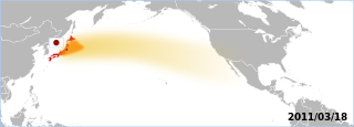
The Fukushima accident's radioactive plume. The map displays areas which have been overflown by the plume. Made by the Graphic Lab/Map workshop's wikigraphists (WP:GL/MAP) Sources 2011/03/18:
Note: Aeronobie.be now ask to cite and follow the Zamg.ac.at's page (currently the main source), stating: '--Varlaam 21:19, 24 March 2011 (UTC)'"The World Meteorological Organisation asked the Central Institute for Meteorology and Geodynamics (or ZAMG, Austria) to support the International Atomic Energy Agency by providing the atmospheric plume calculations." Background based on: A blank map of the world centred at the 180E longitude line. Detailed SVG map with grouping enabled to connect all non-contiguous parts of a country's territory for easy colouring. Smaller countries can also be represented by larger circles to show their data easier. A thorough description of use and other instructions relating to can be found on the instruction page |
||
| Data | (UTC) | ||
| Font | Own work based on: BlankMap-World-180E.svg | ||
| Autor | BlankMap-World-180E.svg: Lokal_Profil / derivative work: Yug | ||
| SVG genesis | El codi font d’aquest SVG no és vàlid perquè hi 4 han errors. Aquesta imatge vectorial ha estat creada amb Inkscape.
|
Llicència
| Jo, el titular del copyright d'aquesta obra, l'allibero al domini públic. Això s'aplica a tot el món. En alguns països això pot no ser legalment possible, en tal cas: Jo faig concessió a tothom del dret d'usar aquesta obra per a qualsevol propòsit, sense cap condició llevat d'aquelles requerides per la llei. |
Registre original de càrregues
This image is a derivative work of the following images:
- File:BlankMap-World-180E.svg licensed with PD-self
- 2008-04-13T22:24:07Z Lokal_Profil 940x477 (3620359 Bytes) {{Information |Description=A blank map of the world centered at the 180E longitude line. Detailed SVG map with grouping enabled to connect all non-contiguous parts of a country's territory for easy colouring. Smaller count
Uploaded with derivativeFX
Historial del fitxer
Cliqueu una data/hora per veure el fitxer tal com era aleshores.
| Data/hora | Miniatura | Dimensions | Usuari/a | Comentari | |
|---|---|---|---|---|---|
| actual | 17:06, 18 març 2011 | 511 × 183 (2,86 Mo) | Yug | reduction of the area, the source go forward USA-Mexico, but don't reach them by 03/20. | |
| 15:18, 18 març 2011 | 511 × 183 (2,86 Mo) | Yug | fix famous "black square bug" ;) | ||
| 15:06, 18 març 2011 | 511 × 183 (2,86 Mo) | Yug | {{Information |Description=Fukushima accident's radioactive cloud. Made by the Graphic Lab/Map workshop's wikigraphists ([[:en:WP:GL/MAP) Sources 2011/03/18: * {{cite web|title=Nouvelle simulation du |
Ús del fitxer
La pàgina següent utilitza aquest fitxer:
Ús global del fitxer
Utilització d'aquest fitxer en altres wikis:
- Utilització a de.wikipedia.org
- Utilització a de.wikinews.org
- Utilització a en.wikipedia.org
- Utilització a fr.wikipedia.org
- Utilització a sh.wikipedia.org
- Utilització a sr.wikipedia.org
- Utilització a uk.wikipedia.org