
Fitxer:Hawaii hotspot.jpg
Mida d'aquesta previsualització: 800 × 337 píxels. Altres resolucions: 320 × 135 píxels | 640 × 270 píxels | 1.500 × 632 píxels.
Fitxer original (1.500 × 632 píxels, mida del fitxer: 452 Ko, tipus MIME: image/jpeg)
| Aquest fitxer i la informació mostrada a continuació provenen del dipòsit multimèdia lliure Wikimedia Commons. |
| Descripció |
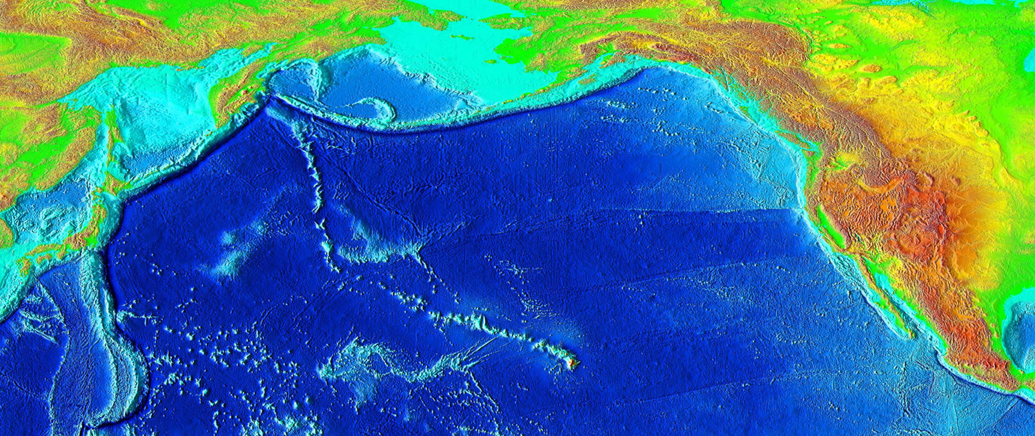
English: The trail of underwater mountains created as the tectonic plate moved across the Hawaii hotspot over millions of years, known as the Hawaiian-Emperor seamount chain, or the Emperor Seamounts. |
|||
| Data | ||||
| Font | http://www.ngdc.noaa.gov/mgg/image/2minrelief.html | |||
| Autor | National Geophysical Data Center/USGS | |||
| Permís (Com reutilitzar aquest fitxer) |
|
| Anotacions | Aquesta imatge té anotacions: Vegeu-les a Commons |
Historial del fitxer
Cliqueu una data/hora per veure el fitxer tal com era aleshores.
| Data/hora | Miniatura | Dimensions | Usuari/a | Comentari | |
|---|---|---|---|---|---|
| actual | 06:42, 7 març 2006 | | 1.500 × 632 (452 Ko) | Interiot~commonswiki | Higher resolution |
| 06:26, 7 març 2006 |  | 1.000 × 421 (201 Ko) | Interiot~commonswiki | The trail of underwater mountains created as the the tectonic plate moved across the Hawaii hotspot over millions of years. Source: http://www.ngdc.noaa.gov/mgg/image/2minrelief.html |
Ús del fitxer
Les 2 pàgines següents utilitzen aquest fitxer:
Ús global del fitxer
Utilització d'aquest fitxer en altres wikis:
- Utilització a ba.wikipedia.org
- Utilització a bg.wikipedia.org
- Utilització a de.wikipedia.org
- Utilització a en.wikipedia.org
- Hawaiian Islands
- Talk:Hawaiian Islands
- Hawaiian–Emperor seamount chain
- Evolution of Hawaiian volcanoes
- Hotspot (geology)
- Portal:Geography/Featured picture/2007, week 2
- Hawaii hotspot
- Portal:Geography/Featured picture archive/2007
- User talk:Resident Mario
- Wikipedia:WikiProject Seamounts/Images
- List of volcanoes in the Hawaiian–Emperor seamount chain
- Plate reconstruction
- Wikipedia:Graphics Lab/Map workshop/Archive/Apr 2012
- Wikipedia:Today's featured list/October 2022
- Wikipedia:Today's featured list/October 21, 2022
- Wikipedia:Main Page history/2022 October 21
- Wikipedia:Main Page history/2022 October 21b
- Utilització a en.wikibooks.org
- Utilització a en.wikinews.org
- Utilització a en.wikiquote.org
- Utilització a en.wikisource.org
- Utilització a en.wikiversity.org
- Utilització a en.wikivoyage.org
- Utilització a eo.wikipedia.org
- Utilització a es.wikipedia.org
- Utilització a eu.wikipedia.org
- Utilització a fa.wikipedia.org
- Utilització a foundation.wikimedia.org
- Utilització a fr.wikipedia.org
- Utilització a he.wikipedia.org
- Utilització a hr.wikipedia.org
- Utilització a it.wikipedia.org
- Utilització a it.wikibooks.org
- Utilització a it.wikiversity.org
- Utilització a ja.wikipedia.org
Vegeu més usos globals d'aquest fitxer.