
Fitxer:Map of the Spanish Conquest of Guatemala.png
Mida d'aquesta previsualització: 552 × 599 píxels. Altres resolucions: 221 × 240 píxels | 442 × 480 píxels | 960 × 1.042 píxels.
Fitxer original (960 × 1.042 píxels, mida del fitxer: 677 Ko, tipus MIME: image/png)
| Aquest fitxer i la informació mostrada a continuació provenen del dipòsit multimèdia lliure Wikimedia Commons. |

|
Aquesta imatge (de tipus mapa) s'hauria de tornar a crear utilitzant gràfics vectorials com ara un fitxer SVG. Això té diversos avantatges; en trobareu més informació a Commons:Media for cleanup. Si ja disposeu d'una versió d'aquesta imatge en format SVG, us preguem que la pengeu; després, reemplaceu aquesta plantilla amb la plantilla {{Vector version available|nom nou de la imatge.svg}} en aquesta imatge.
|
Resum
| Descripció |
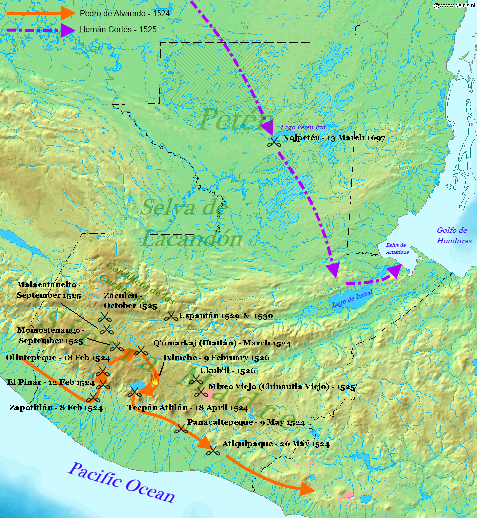
English: Map displaying the principal events of the Spanish Conquest of Guatemala, and the route taken by Pedro de Alvarado. Bounding box West -92.5°, South 13.5°, East -88°, North 18.2°. Center at 15°51′00″N 90°15′00″W / 15.85000°N 90.25000°W. |
| Data | (UTC) |
| Font |
Own work using: |
| Autor |
|
| Això és una imatge retocada, cosa que vol dir que ha estat alterada digitalment de la seva versió original. Modificacions: Added battles of the Spanish conquest and geographical locations. L'original es pot veure a: Map of Guatemala Demis.png:
|
Aquest fitxer està subjecte a la llicència de Creative Commons Reconeixement i Compartir Igual 3.0 No adaptada.
- Sou lliure de:
- compartir – copiar, distribuir i comunicar públicament l'obra
- adaptar – fer-ne obres derivades
- Amb les condicions següents:
- reconeixement – Heu de donar la informació adequada sobre l'autor, proporcionar un enllaç a la llicència i indicar si s'han realitzat canvis. Podeu fer-ho amb qualsevol mitjà raonable, però de cap manera no suggereixi que l'autor us dóna suport o aprova l'ús que en feu.
- compartir igual – Si modifiqueu, transformeu, o generareu amb el material, haureu de distribuir les vostres contribucions sota una llicència similar o una de compatible com l'original
Registre original de càrregues
This image is a derivative work of the following images:
- File:Map_of_Guatemala_Demis.png licensed with PD-Demis
- 2006-12-20T22:49:24Z Mats Halldin 960x1042 (507761 Bytes) Map of [[Guatemala]] Bounding box West -92.5°, South 13.5°, East -88°, North 18.2°. Center at {{coor d|15.85000|N|90.25000|W|scale:2819999}}. {{demis-pd}} [[category:maps of Guatemala]]
Uploaded with derivativeFX
Historial del fitxer
Cliqueu una data/hora per veure el fitxer tal com era aleshores.
| Data/hora | Miniatura | Dimensions | Usuari/a | Comentari | |
|---|---|---|---|---|---|
| actual | 00:34, 29 gen 2012 | | 960 × 1.042 (677 Ko) | Simon Burchell | +battles of Momostenango and Malacatancito, move other text make easier to read |
| 22:47, 28 gen 2012 |  | 960 × 1.042 (677 Ko) | Simon Burchell | +battles of Uspantán | |
| 00:11, 6 oct 2011 |  | 960 × 1.042 (676 Ko) | Simon Burchell | Added route of Hernán Cortés 1525 | |
| 23:25, 5 oct 2011 |  | 960 × 1.042 (669 Ko) | Simon Burchell | {{Information |Description=Map of Guatemala Bounding box West -92.5°, South 13.5°, East -88°, North 18.2°. Center at |Source=*File:Map_of_Guatemala_Demis.png |Date=2011-10-05 21:18 (UTC) |Author=*File:Map_of_Guatemala_Demis.png: Demis |
Ús del fitxer
La pàgina següent utilitza aquest fitxer:
Ús global del fitxer
Utilització d'aquest fitxer en altres wikis:
- Utilització a ar.wikipedia.org
- Utilització a en.wikipedia.org
- Utilització a es.wikipedia.org
- Utilització a fr.wikipedia.org
- Utilització a hu.wikipedia.org
- Utilització a it.wikipedia.org
- Utilització a pnb.wikipedia.org
- Utilització a uk.wikipedia.org
- Utilització a ur.wikipedia.org
- Utilització a vi.wikipedia.org