
Fitxer:Mississippi River map.png

Mida d'aquesta previsualització: 800 × 502 píxels. Altres resolucions: 320 × 201 píxels | 640 × 402 píxels | 1.024 × 643 píxels | 1.386 × 870 píxels.
Fitxer original (1.386 × 870 píxels, mida del fitxer: 47 Ko, tipus MIME: image/png)
| Aquest fitxer i la informació mostrada a continuació provenen del dipòsit multimèdia lliure Wikimedia Commons. |
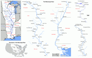
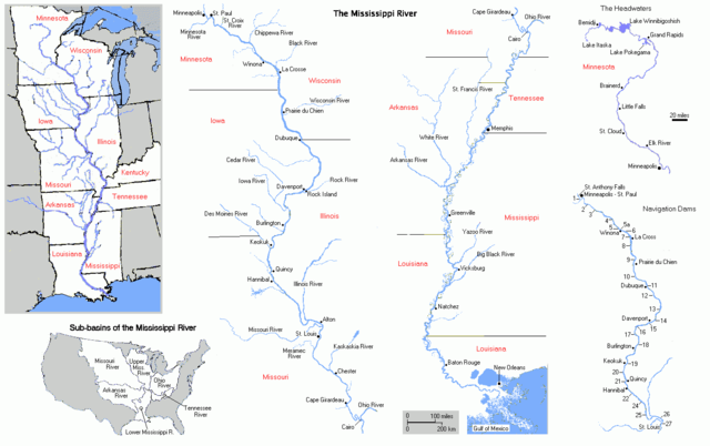
FRom en Wiki by Bluelion. Cite from en wiki:
Map of Mississippi River. I made this map myself and reserve no rights to it. The maps were made by extensively modifying copyright-free maps generated by U.S. Government on-line mapping utilites, either the Department of the Interior's National Atlas of the United States Interactive Map Browser archive copy at the Wayback Machine, or the U.S. Census Bureau's old TIGER Map Browser.
| Jo, el titular del copyright d'aquesta obra, l'allibero al domini públic. Això s'aplica a tot el món. En alguns països això pot no ser legalment possible, en tal cas: Jo faig concessió a tothom del dret d'usar aquesta obra per a qualsevol propòsit, sense cap condició llevat d'aquelles requerides per la llei. |
Historial del fitxer
Cliqueu una data/hora per veure el fitxer tal com era aleshores.
| Data/hora | Miniatura | Dimensions | Usuari/a | Comentari | |
|---|---|---|---|---|---|
| actual | 21:10, 27 juny 2005 | | 1.386 × 870 (47 Ko) | Jan Kronsell | FRom en Wiki by Bluelion. Cite from en wiki: Map of '''''Mississippi River'''''. I made this map myself and '''reserve no rights''' to it. The maps were made by extensively modifying '''copyright-free''' maps generated by U.S. Government on-line mapping |
Ús del fitxer
No hi ha pàgines que utilitzin aquest fitxer.
Ús global del fitxer
Utilització d'aquest fitxer en altres wikis:
- Utilització a am.wikipedia.org
- Utilització a an.wikipedia.org
- Utilització a bn.wikipedia.org
- Utilització a br.wikipedia.org
- Utilització a cv.wikipedia.org
- Utilització a cy.wikipedia.org
- Utilització a da.wikipedia.org
- Utilització a eo.wikipedia.org
- Utilització a gl.wikipedia.org
- Utilització a it.wikipedia.org
- Utilització a la.wikipedia.org
- Utilització a ml.wikipedia.org
- Utilització a ms.wikipedia.org
- Utilització a no.wikipedia.org
- Utilització a pt.wikipedia.org
- Utilització a qu.wikipedia.org
- Utilització a roa-tara.wikipedia.org
- Utilització a scn.wikipedia.org
- Utilització a sl.wikipedia.org
- Utilització a sv.wikipedia.org
- Utilització a ta.wikipedia.org
- Utilització a te.wikipedia.org
- Utilització a war.wikipedia.org
- Utilització a zh.wikipedia.org