
Fitxer:Nansen Franz Josef Land voyage map.svg

Mida d'aquesta previsualització PNG del fitxer SVG: 600 × 438 píxels. Altres resolucions: 320 × 234 píxels | 640 × 467 píxels | 1.024 × 748 píxels | 1.280 × 934 píxels | 2.560 × 1.869 píxels.
Fitxer original (fitxer SVG, nominalment 600 × 438 píxels, mida del fitxer: 400 Ko)
| Aquest fitxer i la informació mostrada a continuació provenen del dipòsit multimèdia lliure Wikimedia Commons. |
Resum
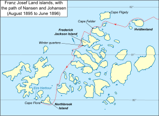
| Descripció | Map of Franz Josef Land archipelago in the Arctic Ocean north of Russia, showing the path of Nansen and Johansen through the islands, August 1895 to June 1896 |
| Data | |
| Font |
Vector version of File:Nansen Franz Josef Land Voyage Map.PNG Aquesta imatge vectorial ha estat creada amb Inkscape . |
| Autor | Dtbohrer |
| Altres versions |
Derivative works of this file: Nansen Franz Josef Land voyage map-fr.svg PNG version |
Llicència
| Jo, el titular del copyright d'aquesta obra, l'allibero al domini públic. Això s'aplica a tot el món. En alguns països això pot no ser legalment possible, en tal cas: Jo faig concessió a tothom del dret d'usar aquesta obra per a qualsevol propòsit, sense cap condició llevat d'aquelles requerides per la llei. |
Historial del fitxer
Cliqueu una data/hora per veure el fitxer tal com era aleshores.
| Data/hora | Miniatura | Dimensions | Usuari/a | Comentari | |
|---|---|---|---|---|---|
| actual | 01:17, 18 oct 2009 | | 600 × 438 (400 Ko) | Niagara | darken latitude lines |
| 03:33, 13 oct 2009 |  | 600 × 438 (401 Ko) | Niagara | == Summary == {{Information |Description = Map of Franz Josef Land archipelago in the Arctic Ocean north of Russia, showing the path of Nansen and Johansen through the islands, August 1895 to June 189 |
Ús del fitxer
La pàgina següent utilitza aquest fitxer:
Ús global del fitxer
Utilització d'aquest fitxer en altres wikis:
- Utilització a ar.wikipedia.org
- Utilització a ast.wikipedia.org
- Utilització a be.wikipedia.org
- Utilització a en.wikipedia.org
- Utilització a es.wikipedia.org
- Utilització a fr.wikipedia.org
- Utilització a hy.wikipedia.org
- Utilització a it.wikipedia.org
- Utilització a ja.wikipedia.org
- Utilització a pt.wikipedia.org
- Utilització a ro.wikipedia.org
- Utilització a zh.wikipedia.org