
Fitxer:SEUtahStrat.JPG

Mida d'aquesta previsualització: 800 × 454 píxels. Altres resolucions: 320 × 182 píxels | 640 × 363 píxels | 1.024 × 581 píxels | 1.280 × 726 píxels | 3.161 × 1.794 píxels.
Fitxer original (3.161 × 1.794 píxels, mida del fitxer: 2,5 Mo, tipus MIME: image/jpeg)
| Aquest fitxer i la informació mostrada a continuació provenen del dipòsit multimèdia lliure Wikimedia Commons. |
Resum
| Descripció |
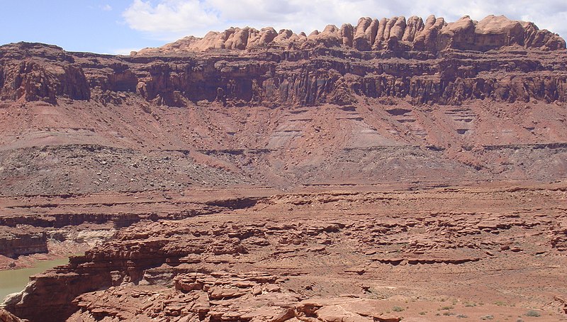
English: The Permian (bottom) through Jurassic (top) stratigraphy of the Colorado Plateau area of southeastern Utah that makes up much of the famous prominent rock formations in protected areas such as Capitol Reef National Park and Canyonlands National Park.
From top to bottom: Rounded tan domes of the Navajo Sandstone, layered red Kayenta Formation, cliff-forming, vertically-jointed, red Wingate Sandstone, slope-forming, purplish Chinle Formation, layered, lighter-red Moenkopi Formation, and white, layered Cutler Formation sandstone. Picture from Glen Canyon National Recreation Area, Utah. (modified version, 26MAY-2012, after change on en:Moenkopi Formation; changing (3) to a (3A,3B), with explanations, because of the larger photo RED debris visible.) The en:Jurassic through en:Permian stratigraphy of the Colorado Plateau area of southeastern Utah that makes up much of the famous prominent rock formations in protected areas such as Capitol Reef National Park and Canyonlands National Park. From top to bottom, (Jurassic to Permian): (6)-Rounded tan domes of the Navajo Sandstone, (5)-(very-dark)-layered red Kayenta Formation, (4)-(very-dark)-cliff-forming, vertically-jointed, red Wingate Sandstone, (3B)-(RED debris covered)-slope-forming, purplish Chinle Formation, (3A)-(NO RED Debris)-slope-forming, purplish Chinle Formation, (2)-layered, lighter-red Moenkopi Formation, and (1)-white, layered Cutler Formation sandstone. Picture from Glen Canyon National Recreation Area, Utah.)- (this makes 7 Layers, or there are 6 Layers with 3A, and 3B) |
| Data | (UTC) (Uploaded on Commons at 2011-03-27 17:26:30 (UTC)/Original uploaded at 2010-05-20 16:46:26) |
| Font | I (Matt Affolter (QFL247) (talk)) created this work entirely by myself. (Original uploaded on en.wikipedia) |
| Autor | Matt Affolter (QFL247) (talk) (Transferred by Citypeek/Original uploaded by Matt Affolter (QFL247)) |
Llicència
Matt Affolter (QFL247), el titular dels drets d'autor d'aquest treball, el public sota les següents llicències:
Aquest fitxer està subjecte a la llicència de Creative Commons Reconeixement i Compartir Igual 3.0 No adaptada.
Reconeixement: Matt Affolter (QFL247)
- Sou lliure de:
- compartir – copiar, distribuir i comunicar públicament l'obra
- adaptar – fer-ne obres derivades
- Amb les condicions següents:
- reconeixement – Heu de donar la informació adequada sobre l'autor, proporcionar un enllaç a la llicència i indicar si s'han realitzat canvis. Podeu fer-ho amb qualsevol mitjà raonable, però de cap manera no suggereixi que l'autor us dóna suport o aprova l'ús que en feu.
- compartir igual – Si modifiqueu, transformeu, o generareu amb el material, haureu de distribuir les vostres contribucions sota una llicència similar o una de compatible com l'original

|
S'autoritza la còpia, la distribució i la modificació d'aquest document sota els termes de la llicència de documentació lliure GNU versió 1.2 o qualsevol altra versió posterior que publiqui la Free Software Foundation; sense seccions invariants, ni textos de portada, ni textos de contraportada. S'inclou una còpia d'aquesta llicència en la secció titulada GNU Free Documentation License. |
Podeu seleccionar la llicència que vulgueu.
Registre original de càrregues
La pàgina de descripció original era aquí. Els noms d'usuari a continuació es refereixen a en.wikipedia.
- 2010-05-20 16:46:26 Qfl247 3,161×1,794 (2.5 MB) ({{Information |Description = The [[Permian]] through [[Jurassic]] stratigraphy of the [[Colorado Plateau]] area of southeastern [[Utah]] that makes up much of the famous prominent rock formations in protected areas such as [[Capitol Reef National Park)
Historial del fitxer
Cliqueu una data/hora per veure el fitxer tal com era aleshores.
| Data/hora | Miniatura | Dimensions | Usuari/a | Comentari | |
|---|---|---|---|---|---|
| actual | 19:27, 27 març 2011 | | 3.161 × 1.794 (2,5 Mo) | Citypeek | {{BotMoveToCommons|en.wikipedia|year={{subst:CURRENTYEAR}}|month={{subst:CURRENTMONTHNAME}}|day={{subst:CURRENTDAY}}}} The upload bot is User:CommonsHelper2 Bot which is called by [http://toolserver.org/~commonshelper2/index.php CommonsHelper2]. The t |
Ús del fitxer
Les 2 pàgines següents utilitzen aquest fitxer:
Ús global del fitxer
Utilització d'aquest fitxer en altres wikis:
- Utilització a ar.wikipedia.org
- Utilització a be-tarask.wikipedia.org
- Utilització a bg.wikipedia.org
- Utilització a bs.wikipedia.org
- Utilització a cs.wikipedia.org
- Utilització a de.wikipedia.org
- Utilització a en.wikipedia.org
- Geology
- Sedimentary rock
- Stratigraphy
- Lithology
- Stratum
- Colorado Plateau
- Grand Staircase
- Glen Canyon National Recreation Area
- Geological formation
- Geology of the Canyonlands area
- Geology of the Capitol Reef area
- Stratigraphic unit
- Lithostratigraphy
- Principle of original horizontality
- Relative dating
- Navajo Sandstone
- Moenkopi Formation
- Chinle Formation
- Glen Canyon Group
- Wingate Sandstone
- Kayenta Formation
- Principle of lateral continuity
- Stratigraphic section
- User:Qfl247/pics
- User:Rygel, M.C./SedimentaryRock Sandbox
- User:Abyssal/Portal:Permian/Natural world articles/33
- User:Abyssal/Portal:Triassic/Natural world articles/32
- User:Abyssal/Portal:Jurassic/Natural world articles/31
- User:Abyssal/Portal:Paleogene/Natural world articles/33
- User:Abyssal/Portal:Cenozoic/Natural world articles/33
- User:Abyssal/Portal:Neogene/Natural world articles/32
- Utilització a en.wikiversity.org
Vegeu més usos globals d'aquest fitxer.