
Fitxer:Map boatlifts canal du centre.svg

Mida d'aquesta previsualització PNG del fitxer SVG: 534 × 375 píxels. Altres resolucions: 320 × 225 píxels | 640 × 449 píxels | 1.024 × 719 píxels | 1.280 × 899 píxels | 2.560 × 1.798 píxels.
Fitxer original (fitxer SVG, nominalment 534 × 375 píxels, mida del fitxer: 418 Ko)
| Aquest fitxer i la informació mostrada a continuació provenen del dipòsit multimèdia lliure Wikimedia Commons. |
Resum
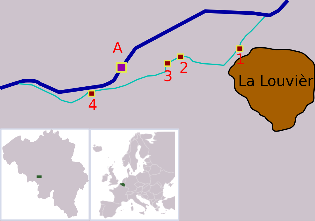
| Descripció | Map showing the locations of the four boatlifts on Canal du Centre, Belgium. The boatlifts are a UNESCO world heritage site. The numbers correspond with the UNESCO inscription, "A" is the new boatlift that replaced them. |
| Data | |
| Font |
Treball propi Aquesta imatge vectorial ha estat creada amb Inkscape . |
| Autor | Finnrind |
Llicència
I, Finnrind, el titular dels drets d'autor d'aquest treball, el public sota les següents llicències:

|
S'autoritza la còpia, la distribució i la modificació d'aquest document sota els termes de la llicència de documentació lliure GNU versió 1.2 o qualsevol altra versió posterior que publiqui la Free Software Foundation; sense seccions invariants, ni textos de portada, ni textos de contraportada. S'inclou una còpia d'aquesta llicència en la secció titulada GNU Free Documentation License. |
| Aquest fitxer està subjecte a la llicència de Creative Commons Reconeixement i Compartir Igual 3.0 No adaptada. | ||
| Reconeixement: I, Finnrind | ||
| ||
| Aquest avís de llicència s'ha afegit a aquest fitxer d'acord amb l'actualització de la llicència GFDL. |
Aquest fitxer està llicenciat sota les llicències de Creative Commons Reconeixement - CompartirIgual 2.5 Genèrica, 2.0 Genèrica i 1.0 Genèrica.
Reconeixement: I, Finnrind
- Sou lliure de:
- compartir – copiar, distribuir i comunicar públicament l'obra
- adaptar – fer-ne obres derivades
- Amb les condicions següents:
- reconeixement – Heu de donar la informació adequada sobre l'autor, proporcionar un enllaç a la llicència i indicar si s'han realitzat canvis. Podeu fer-ho amb qualsevol mitjà raonable, però de cap manera no suggereixi que l'autor us dóna suport o aprova l'ús que en feu.
- compartir igual – Si modifiqueu, transformeu, o generareu amb el material, haureu de distribuir les vostres contribucions sota una llicència similar o una de compatible com l'original
Podeu seleccionar la llicència que vulgueu.
Historial del fitxer
Cliqueu una data/hora per veure el fitxer tal com era aleshores.
| Data/hora | Miniatura | Dimensions | Usuari/a | Comentari | |
|---|---|---|---|---|---|
| actual | 21:08, 15 jul 2007 | | 534 × 375 (418 Ko) | Finnrind | |
| 20:31, 15 jul 2007 |  | 534 × 375 (412 Ko) | Finnrind | ||
| 20:25, 15 jul 2007 |  | 534 × 375 (412 Ko) | Finnrind | ||
| 20:21, 15 jul 2007 |  | 258 × 183 (151 Ko) | Finnrind | {{Information |Description=Map showing the locations of the four boatlifts on Canal du Centre, Belgium. The boatlifts are a UNESCO world heritage site. The numbers correspond with the UNESCO inscription, "A" is the new boatlift that replaced them. |Source |
Ús del fitxer
La pàgina següent utilitza aquest fitxer:
Ús global del fitxer
Utilització d'aquest fitxer en altres wikis:
- Utilització a de.wikipedia.org
- Utilització a en.wikipedia.org
- Utilització a eo.wikipedia.org
- Utilització a es.wikipedia.org
- Utilització a fi.wikipedia.org
- Utilització a fr.wikipedia.org
- Utilització a gl.wikipedia.org
- Utilització a he.wikipedia.org
- Utilització a hr.wikipedia.org
- Utilització a hu.wikipedia.org
- Utilització a lt.wikipedia.org
- Utilització a mt.wikipedia.org
- Utilització a nl.wikipedia.org
- Utilització a no.wikipedia.org
- Utilització a pl.wikipedia.org
- Utilització a pt.wikipedia.org
- Utilització a ro.wikipedia.org
- Utilització a ru.wikipedia.org
- Utilització a sh.wikipedia.org
- Utilització a sr.wikipedia.org
- Utilització a zh.wikipedia.org